Yalakhuntum (Laos)-Bo Y (Vietnam)
The border crossing between Bo Y and Yalakhuntum, on the 18B (113 km from Attapeu), is open daily 08:00-16:00.30-day Laos visas are issued at the border. Vietnamese visas are not available at the border and will need to be obtained in advance. Two buses leave Attapeu for Pleiku in Vietnam, 110 km.
The nearest Vietnamese embassy is based in Pakse, No 24 Road. If you are in a rush however, Xplore Asia offers a one-working day visa service.
Tad Yeung and around
Around 2 km from Tad Fan and 40 km from Pakse is Tad Yeung. The falls are about 1km from the main road. Set among beautiful coffee plantations and sprinkled with wooden picnic huts, these falls are possibly the best on offer on the plateau as they offer both height and accessibility. Packing a picnic in Pakse and bringing it along for an afternoon trip is recommended. The cascades plummet 50 m to a pool at the bottom, where it’s possible to swim in the dry season. During the wet season the waterways create numerous little channels and islands around the cascades. Behind the main falls sits a cave, however it’s best to get someone to guide you here. There is a slippery walkway from the top of the falls to the bottom, where you can swim. The falls can be reached by taking a local bus from the Southern bus terminal in Pakse to a village at Km 40 (ask to go to Lak See Sip). The turn-off is on the right from Pakse (and on the left from Paksong). There is a sign on the main road which indicates Sihom Sabaidy Guesthouse, follow this road about 700 m to the falls. These falls are a great option if you are trying to avoid the backpacker hordes.
Just 17 km from Paksong are the twin falls of Tad Mone and Tad Meelook. Once a popular picnic spot for locals, the area is now almost deserted and the swimming holes at the base of the falls are an idyllic place for a dip.
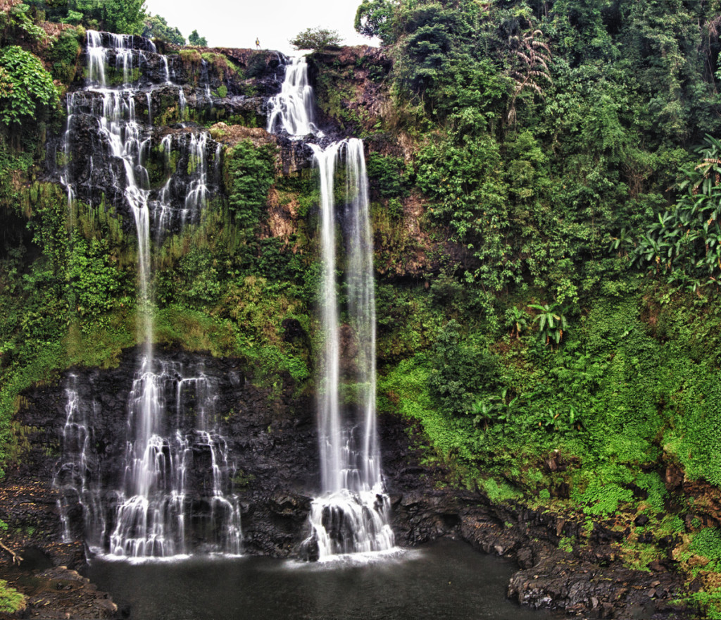
Tad Yeung waterfall
Some 35 km northwest of Pakse is Pasuam Waterfall and Utayan Bajiang Champasak, a strange ethnic theme park popular with Thai tourists. The large compound features small cascades, a model ethnic village, gardens and trails. There are bungalows, a tree house and rooms available. To get here from Pakse follow Route 13 towards Paksong and follow the left fork at 21 km and turn off at 30 km.
Tad Lo and around
Tad Lo is a popular ‘resort’ on the edge of the Bolaven Plateau, nestled alongside three rolling cascades. There are several places to stay in this idyllic retreat, good hiking, a river to frolic in (especially in the wet season) and elephant trekking. In the vicinity of Tad Lo there are also several villages, which can be visited in the company of a local villager. The guesthouses in Tad Lo can arrange guided treks to Ban Khian and Tad Soung.
The Xe Xet (or Houai Set) flows past Tad Lo, crashing over two sets of cascades nearby: Tad Hang, the lower series, is overlooked by the Tad Lo Lodge and Saise Guesthouse, while Tad Lo, the upper, is a short hike away.
A new Community Guides office has been established with a number of trained guides offering treks around the Tad Lo area and to nearby Ngai villages. Elephant treks can also be arranged from the Tad Lo Lodge for trekking through the jungle and river.
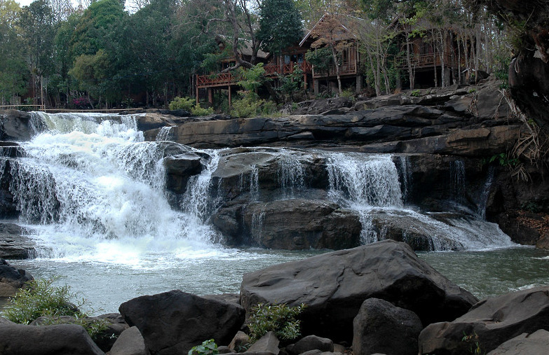
Tad Lo Waterfall in Laos
There are two Alak villages, Ban Khian and Tad Soung, close to Tad Lo. Tad Soung is approximately 10 km away from the main resort area and are the most panoramic falls in the vicinity. The Alak are an Austro-lndonesian ethno-linguistic group. Most fascinating is the Alak’s seeming obsession with death. The head of each household carves coffins out of hollowed logs for himself and his whole family (even babies), then stacks them, ready for use, under their rice storage huts. This tradition serves as a reminder that life expectancy in these remote rural areas is around 40 and infant mortality of around 100 per 1000 live births; the number-one killer is malaria.
Katou villages such as Ban Houei Houne (on the Salavan-Pakse road) are famous for their weaving of a bright cloth used locally as a pha sinh (sarong).
Don Khong
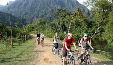
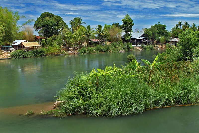
Don Khong is the largest of the Mekong islands at 16 km long and 8 km wide. It’s the place to relax or explore by bicycle. Visitors might be surprised by the smooth asphalt roads, electricity and general standard of amenities that exist on the island but two words explain it all – Khamtay Siphandone – Laos’ former president, who has a residence on the island.
Arriving in Don Khong
Getting there and around The easiest way to get to all three major Siphandon islands from Pakse is by private minivan arranged by operators in Pakse. The luxurious way is aboard the Vat Phou, www.vatphou.com, a boutique riverborne hotel that does a three-day/two-night cruise from Pakse to Champasak and Wat Phou to Don Khong, returning to Pakse.
Songthaews depart Pakse’s Southern bus terminal hourly between 08:00 and 12:00. The occasional bus will also ply the route, but songthaews are the most common transport option. The journey to Ban Hat Xai Khoune (to catch a boat to Don Khong) should take between four and five; in most cases the bus/truck will board the car ferry at Ban Hat (1 km south of Ban Hat Xai Khoune) and take you right across to Ban Naa on Don Khong (1 km south of Muang Khong). Motorbikes on the car ferry from Ban Hat are charged. There are also motorboats from Ban Hat Xai Khoune to Muang Khong. Passenger boats stop before dark in the wet season but may run a little later when it is dry.
If there is not a bus directly to Don Khong, catch a bus bound for Ban Nakasang (the stop-off for Don Deth and Don Khone) and jump off at Ban Hat Xai Khoune. All local guesthouses are able to arrange bicycle hire.
Around the island
Don Khong’s ‘capital’ is Muang Khong, a small former French settlement. Pigs and chickens scrabble for food under the houses and just 50 m inland the houses give way to paddy fields. There are two wats in the town. Wat Kan Khong, also known as Wat Phuang Kaew, is visible from the jetty: a large gold Buddha in the mucfra of subduing Mara garishly overlooks the Mekong. Much more attractive is Wat Chom Thong at the upstream extremity of the village, which may date from the early 19th century but which was much extended during the colonial period. The unusual Khmer-influenced sim may be gently decaying but it is doing so with style. The wat compound, with its carefully tended plants and elegant buildings, is very peaceful. The naga heads on the roof of the main sim are craftily designed to channel water, which issues from their mouths.
Most people come to Muang Khong as a base for visiting the Li Phi and Khong Phapheng Falls in the far south. However, visiting the falls and the dolphins is much easier to arrange on Don Deth or Don Khone. This island is a destination in itself and offers a great insight into Lao rural life without all the hustle and bustle found in more built-up areas. To a certain extent, except for electricity, a sprinkling of cars and the increasing number of brightly painted brick houses, time stands still on Dong Khong.
The island itself is worth exploring by bicycle and deserves more time than most visitors give it. It is flat – except in the interior where there are approximately 99 hills – the roads are quiet, so there is less risk of being mown down by a timber truck, and the villages and countryside offer a glimpse of traditional Laos. Most people take the southern loop around the island, via Ban Muang Saen Nua, or Muang Sen, a distance of about 25 km (two to three hours by bike).The villages along the section of road south of Ban Muang Saen Nua are picturesque with buffalos grazing and farmers tending to their rice crops. Unlike other parts of Laos the residents here are fiercely protective of their forests and logging incurs very severe penalties.
About 6 km north of Ban Muang Saen Nua is a hilltop wat, which is arguably Don Khong’s main claim to national fame. Wat Phou Khao Kaew (Glass Hill Monastery), which features a pre-Angkor era lintel, is built on the spot where an entrance leads down to the underground lair of the nagas, known as Muang Nak.This underground town lies beneath the waters of the Mekong, with several tunnels leading to the surface (another is at That Luang in Vientiane). Lao legend has it that the nagas will come to the surface to protect the Lao whenever the country is in danger. Tham Phou Khiaw is tucked away among the forests of the ‘Green Mountain’ in the centre of the island. It’s a small cave, containing earthenware pots, Buddha images and other relics. Every Lao New Year (April) townsfolk climb up to the cave to bathe the images. Although it’s only 15 minutes’ walk from the road, finding the cave is not particularly straightforward except during Lao New Year when it is possible to follow the crowds. Head 1.5 m north from Muang Khong on the road until you come to a banana plantation just before a school, with a couple of wooden houses. Take the path, marked by light colored stones, just before the houses through the banana plantation and at the top, just to the left, is a small gateway through the fence and a fairly well-defined path. Head up and along this path and, after 300 m or so, there is a rocky clearing. The path continues from the top right corner of the clearing for a further 200 m to a rocky mound that rolls up and to the left. Walk across the mound for about 20 m, until it levels out, and then head back to the forest. Keeping the rock immediately to your right, continue round and after 40 m there are two upturned tree trunks marking the entrance to the cave.
On the northern tip of the island is a sandy beach. Note that swimming is generally not advised due to parasites in the water and potentially strong currents. There is a rumour that Laos’ former president, Khamtay Siphandone, is building a resort here. Nearthe unremarkable Wat Houa Khong, approximately 13 km north of Muang Khong, is the former president’s modest traditional Lao-style abode.
Don Deth, Don Khone and around
Don Khone Island on the Mekong River in Southernmost Laos
The islands of Don Khone and Don Deth are the pot of gold at the end of the rainbow for most travellers who head to the southern tip of Laos, and it’s not hard to see why. The bamboo huts that stretch along the banks of these two staggeringly beautiful islands are filled with contented travelers in no rush to move on. Don Deth is more of a backpacker haven, meanwhile Don Khone has been able to retain a more authentically Lao charm. Travelling by boat in this area is very picturesque: the islands are covered in coconut palms, flame trees, stands of bamboo, kapok trees and hardwoods; the river is riddled with eddies and rapids. In the distance, a few kilometers to the south, are the Khong Hai Mountains, which dominate the skyline and delineate the border between Laos and Cambodia.
In the area are the Li Phi (or Somphamit) Fall and Khong Phapheng Falls – the latter are the largest in Southeast Asia and reputedly the widest in the world.
The French envisaged Don Deth and Don Khone as strategic transit points in their grandiose masterplan to create a major Mekong highway from China. In the late 19th century, ports were built at the southern end of Don Khone and at the northern end of Don Deth and a narrow-gauge railway line were constructed across Don Khone in 1897 as an important bypass around the rapids for French cargo boats sailing upriver from Phnom Penh. In 1920, the French built a bridge across to Don Deth and extended the railway line to Don Deth port. This 5-km stretch of railway has the unique distinction of being the only line the French ever built in Laos. On the southern side of the island lie the rusted corpses of the old locomotive and boiler car. Before pulling into Ban Khone Nua, the main settlement on Don Khone, Don Deth’s original report is on the right, with what remains of its steel rail jetty.
Arriving in Don Deth and Don Khone
A number of companies run tours to this area, especially from Pakse. To get to Don Deth or Don Khone independently from Pakse the bus/songthaew will need to drop you off at Ban Nakasang. This is not the most pleasant of Lao towns and several travellers have complained about being ripped off here. However, it has a thriving market, where most of the islanders stock up on goods, so it’s worth having a look around before you head off, particularly if you need to pick up necessities like torches and batteries. It’s a 500-m walk from the bus stop down to the dock. The ticket office is located in a little restaurant to the right-hand side of the dock. However, you can ask anyone that’s jumping across to the islands for a lift, at a dramatically reduced rate. The boats take about 15 to 20 minutes to make the easy trip to the. Prices will be higher if you are travelling solo, alternatively you can walk between the two islands, cross the bridge. Both islands can easily be navigated on foot or bicycles can be rented from guesthouses.
Now that there are no banks on the islands; some guesthouses will change money and shops are now also changing traveller’s cheques. Mr Phao of Phao’s Riverview on Don Deth will take you by boat to Ban Khinak, north of Ban Nakasang where there is a Visa and MasterCard ATM.
Don Deth
The riverbank here is peppered with cheap-as-chips bamboo huts and restaurants geared to accommodate the growing wave of backpackers that flood south to stop and recoup in this idyllic setting. The peace is increasingly being broken by the sound of construction, however – at the time of writing we saw four places going up on the sunset side alone. That said, enough tranquility remains that a good book, hammock and icy beverage is the order of the day here, but those with a bit more energy should explore the truly stunning surroundings. It’s a great location for watching the sunrises and sunsets, for walking through shady palms and frangipani trees and for swimming off the beaches, which attract the hordes in the dry season. Away from the picturesque waterfront, the centre of the island comprises rice paddies and farms; you should take care not to harm crops when exploring the island.
The national tourism authorities have been coordinating with locals to ensure that the beautiful island doesn’t become ‘Vang Vieng-ified’, so you’ll find no Friends DVDs here, although ‘happy’ shakes have started appearing along with homogenous bars with TVs near the boat landing. The islands received 24-hour electricity in November 2009 although not everyone has signed up to the 24-hour connection. There are no cars (except for the odd truck and tourist open-sided buses) and few other modern conveniences. Internet has amazingly made its way to the island, however, and there is good mobile phone coverage. Most guesthouses run tours to the falls/dolphins. A few entrepreneurial types are starting to promote adventure tourism here. Kayaking and rafting trips can be organized through Xplore Asia, www.xplore-asia.com. Several guesthouses also have tubes for rent. It is definitely inadvisable to go tubing in the wet season and probably not a good idea all year round. It is also inadvisable to go alone; there are a huge set of falls at the bottom of Laos. Swimming, visiting the falls and other activities all need to be undertaken with the utmost caution here. The river’s current is probably the strongest in all of Laos and several tourists have drowned here.
Don Khone
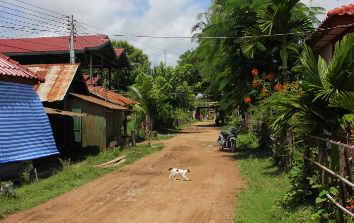
Village in Don Khone, Laos.
From the railway bridge, follow the southwest path through Ban Khone Thai and then wind through the paddy fields for 1.7 km (20 minutes’ walk) to Li Phi Falls, paid at the bridge. Also known as Somphamit or Khone Yai Falls, these are a succession of rapids, crashing through a narrow drop of the Mekong. In the wet season, when the rice is green, the area is beautiful; in the dry season, it is scorching. From the main vantage point on a jagged, rocky outcrop, the roar of the water and the sheer volume pumping through is awe inspiring. ‘Phi’ means ghost, a reference, it is believed, to the bodies that floated down the river from the north during the war. It’s best to visit Li Phi around June or July, when all the fishermen are putting out their bamboo fish traps. As the plentiful signs say, these are dangerous waterfalls; do not swim here.
The Mekong, south of Don Khone, is one of the few places in the world where it is possible to see very rare freshwater dolphins. They can be spotted from December to May, from the French pier at the end of the island, not far from the village of Ban Hang Khon. The walk across Don Khone from the railway bridge is some 4 km and bicycles can be hired. (A much better bicycle route is to head north round the tip and down to Flang Khon, 45 minutes; the disused railway bridge is not a comfortable ride for bikes as it’s rocky.) It is more likely, however, to catch a glimpse of the dolphins if you’re in a boat (from Ban Kong Ngay or Ban Hang Khon), as they reside in deep-water pools. There are thought to be 80-120 dolphins. The Laos-Cambodia border transects the dolphin pool and the Lao boatmen Cambodian authorities in order to access the waters in which the dolphins live. Cambodia gets a bit tetchy about these ‘border incursions’ and may, on the odd occasion, deny access.
Khong Phapheng Falls
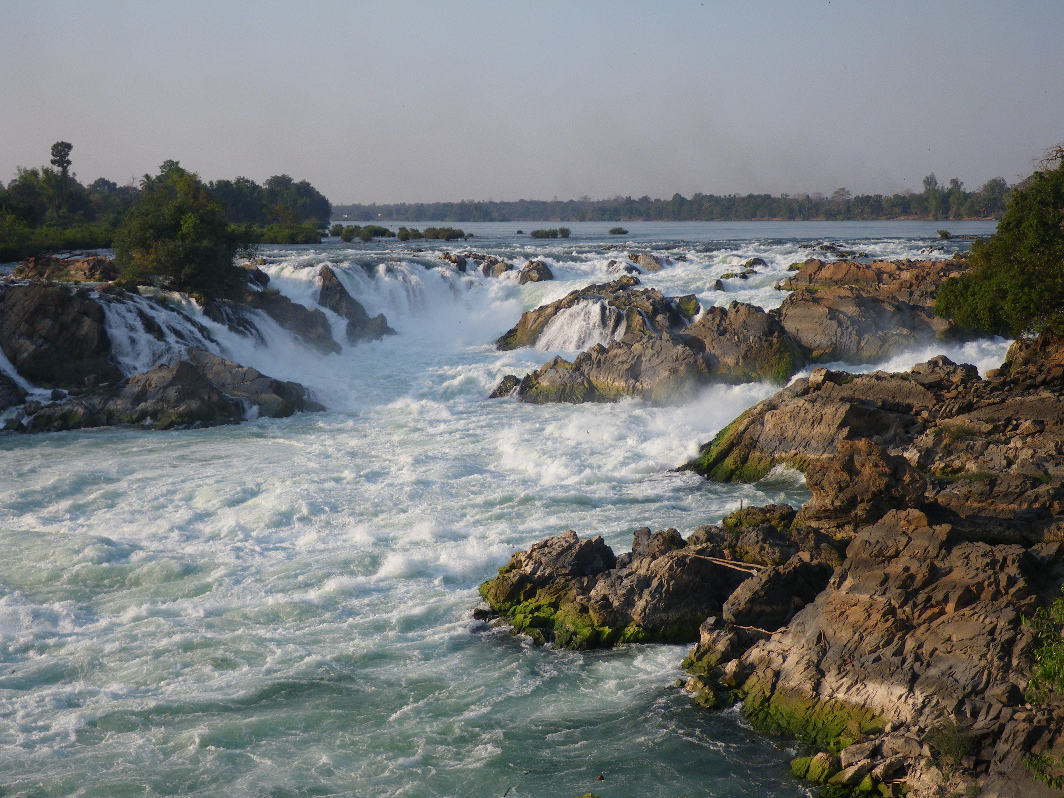
About 36 km south of Ban Hat Xai Khoune at Ban Thatkho, a road branches off Route 13 towards Khong Phapheng Falls, which roar around the eastern shore of the Mekong for 13 km. One fork of the road leads to a vantage point, where a large wooden structure, built up on stilts, overlooks the cascades for a fantastic head-on view of the falls. When you see the huge volume of white water boiling and surging over the jagged rocks below, it is hard to imagine that there is another 10 km width of river running through the other channels. A path leads down from the viewpoint to the edge of the water, be very careful here. Unsurprisingly, the river is impassable at this juncture. Another road leads down to the bank, 200m away, just above the lip of the falls; at this deceptively tranquil spot, the river is gathering momentum before it plunges over the edge.